← All projects/Space/No. 36
2020 · Space · Municipality of Sipoo

Nikkilä Colour Analysis

Extracting Nikkilä’s actual palette of building colours from hundreds of geotagged street photos, using computer vision — turning a subjective design question into area-specific, RAL-coded planning guidance.

Nikkilä Colour Analysis

Following the heritage building survey, Sipoo needed something more specific: concrete colour guidance for how buildings in different parts of Nikkilä should be repaired, extended, or newly built, grounded in what was actually there rather than a designer’s taste.

Built directly on the earlier heritage/typomorphology survey of Nikkilä, refining and applying its area boundaries to a new computer-vision colour analysis — the third phase of a continuing engagement with the Municipality of Sipoo and partner Livady. The method reused and refined an approach SPIN Unit first developed for a 2019 colour analysis of Narva’s wooden-house district in Estonia.

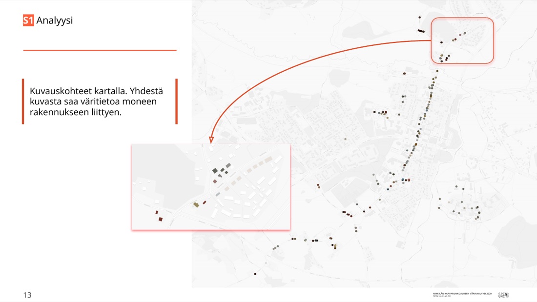
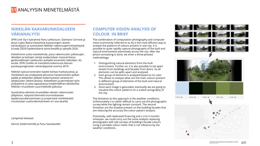
Roughly 360 geocoded photographs were taken across Nikkilä’s built and natural environment. A three-stage computer-vision pipeline segmented natural from built elements, further separated facades, streets, and details, then extracted each element’s dominant colours — mapped back onto the city using each photo’s geolocation. Recommendations were split by intervention type: repair of existing historic buildings, context-respecting infill, and significant new construction.

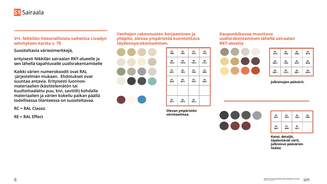
Delivered as a 16-page branded report with a condensed client-facing version, covering four sub-areas of Nikkilä, each with recommended RAL Classic and RAL Effect colour codes.
2 reports to download
About the project
ClientMunicipality of Sipoo
PlaceNikkilä, Sipoo, Finland
Year2020
LensSpace
TopicsColour Planning, Computer Vision, Heritage
What we found
Colour-zone boundaries were anchored to the earlier heritage survey, not drawn arbitrarily — colour policy follows preservation value and building typology, not just geography.
Recommendations are genuinely differentiated by what’s being built: repair of historic buildings, contextual infill, and bold new construction each get distinct palettes within the same zone.
The village/manor landscape area was steered toward muted red and yellow ochre with unpainted or tarred timber; the former hospital/heritage area toward greys and dark reds reflecting its early-20th-century brick materials; new-build zones near the town centre toward bolder greens, oranges, and turquoise.
The team openly reported the method’s limitations — inconsistent weather and lighting during the photo survey, and shadows reducing colour accuracy — and proposed a portable colour-meter field survey as a next-step improvement rather than overselling the photo-based method.
One area, the Jokilaakso river valley, was deliberately excluded because it already had its own dedicated colour plan — disciplined scoping rather than claiming blanket coverage.
Pictures

More space projects

All 61 →
Space
Strelka KB
2020
SPIN Unit · Helsinki — Tallinn
Project record No. 37
Lens:
Space
Reports:
1
Ethical Use of Urban Data
SPIN UnitRead the record →
Space
City of Narva
2020
SPIN Unit · Helsinki — Tallinn
Project record No. 35
Lens:
Space
Reports:
2
ReCenter Narva — Youth Vision for Narva 2035
SPIN UnitRead the record →
Space
UNDP Armenia
2020
SPIN Unit · Helsinki — Tallinn
Project record No. 39
Lens:
Space
Reports:
1
metaMorphology analysis of Yerevan Circular Park
SPIN UnitRead the record →
Space
ALA Architects
2020
SPIN Unit · Helsinki — Tallinn
Project record No. 32
Lens:
Space
Reports:
1
Porvoo Square Benchmark
SPIN UnitRead the record →
Space
City of Warsaw
2019
SPIN Unit · Helsinki — Tallinn
Project record No. 31
Lens:
Space
Reports:
—
Warsaw Spatial Development Scenarios
SPIN UnitRead the record →